Wednesday 25 September 2024: Difference between revisions
| Line 29: | Line 29: | ||
=== North Kaibab and down === | === North Kaibab and down === | ||
One of the nice things about my Garmin InReach Mini is that it offers unlimited (even on the cheap recreational plan) unlimited "Check-ins". This just sends a quick message to whomever you specify that "I'm checking in, everything's fine". I agreed with Elizabeth up-front that I'd send these about every hour just so she didn't worry. You can see one of these messages below, and it shows your current location as well. I also signed up for Garmin's "[https://www.garmin.com/en-US/p/906397 SOS Rescue Insurance]" to defray the cost of a potentially expensive helicopter rescue, should it be needed.<br> | One of the nice things about my Garmin InReach Mini is that it offers unlimited (even on the cheap recreational plan) unlimited "Check-ins". This just sends a quick message to whomever you specify that "I'm checking in, everything's fine". I agreed with Elizabeth up-front that I'd send these about every hour just so she didn't worry. You can see one of these messages below, and it shows your current location as well. I also signed up for Garmin's "[https://www.garmin.com/en-US/p/906397 SOS Rescue Insurance]" to defray the cost of a potentially expensive helicopter rescue, should it be needed.<br> | ||
The first several miles down hill I didn't take any pictures, because it was so dark and technically difficult. I tried to keep up a good pace, the fastest I thought I could safely do | |||
<hovergallery maxhoverwidth=1200 maxhoverheight=1024> | <hovergallery maxhoverwidth=1200 maxhoverheight=1024> | ||
Image:IMG_1382.jpeg|"Checking In" on trail | Image:IMG_1382.jpeg|"Checking In" on trail | ||
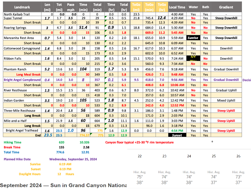
Image:Pace Chart.png|Pace Chart for the hike | |||
</hovergallery> | </hovergallery> | ||
[[Image:xxx.jpeg]]<br> | [[Image:xxx.jpeg]]<br> | ||
[[Image:Pace Chart.png]]<br> | |||
<br> | <br> | ||
Go back to [[Tuesday 24 September 2024|Tuesday the 24th]] or on to [[Thursday 26 September 2024|Thursday the 26th]]<br> | Go back to [[Tuesday 24 September 2024|Tuesday the 24th]] or on to [[Thursday 26 September 2024|Thursday the 26th]]<br> | ||
Revision as of 17:13, 6 October 2024
Sunday 22nd | Monday 23rd | Tuesday 24th | Wednesday 25th | Thursday 26th | Friday 27th | Saturday 28th | Sunday 29th |
Wednesday 25 September
The Rim-to-Rim / R2R / Rim2Rim Hike - Getting Started!
Like I mentioned yesterday, we all piled into bed early after dinner in the North Rim Lodge, and agreed to meet at the van by 3:25 am, and to be on trail by 3:30 am. I was up at 1:30, putting glide on my nipples and pretty much everything from mid thigh to belt line to avoid getting chafed by salt or just general rubbing friction. I drank a bottle of LMNT electroltyes, and made 2 more bottles up, and filled my hydration bladder. I rechecked my backpack had everything, nutrition, cameras and batteries, emergency gear and medicines, water filtration, headlamp, etc. I was ready early, and nervous... like when I did the marathon, and wasn't totally sure I could do it. At 3 am I woke Elizabeth, and started loading my stuff into the van while she got ready. Then it was time.
When I got to the van John and Tammy were walking up with their stuff. It was crisp and cool, mid 50's F. Everyone was in a good mood, but a bit nervous. We piled into the van and quickly covered the 2 miles to the trailhead. John was eager to get on trail, and skipped parking or hitting to pit latrines before getting on trail. That caused me to rush getting my cameras and sound gear full setup, as they were getting their packs on and getting their headlamps and flashing red LED rear markers running. It was much cooler at the trailhead, in the 40's with occasional gusty wind. We got a couple of quick pictures and then headed down the North Kaibab Trail. We were on our way by 3:30 am.
Getting on trail - North Kaibab Trailhead
North Kaibab and down
One of the nice things about my Garmin InReach Mini is that it offers unlimited (even on the cheap recreational plan) unlimited "Check-ins". This just sends a quick message to whomever you specify that "I'm checking in, everything's fine". I agreed with Elizabeth up-front that I'd send these about every hour just so she didn't worry. You can see one of these messages below, and it shows your current location as well. I also signed up for Garmin's "SOS Rescue Insurance" to defray the cost of a potentially expensive helicopter rescue, should it be needed.
The first several miles down hill I didn't take any pictures, because it was so dark and technically difficult. I tried to keep up a good pace, the fastest I thought I could safely do
Go back to Tuesday the 24th or on to Thursday the 26th


